
On Wed, Mar 22, Anita Gutierrez, Supervising Regional Planner for Los Angeles County Department of Regional Planning, notified Roger Pugliese and Joseph Rosendo, members of the Topanga Canyon Boulevard Roadside Committee, that the Director of Caltrans, Malcolm Dougherty, has designated a section of Topanga Canyon Boulevard, along the S-Curves from Jalan Jalan to the coast, as the first scenic highway to be named in more than 40 years in Los Angeles County.
Messenger Mountain News learned from geologist Vicki Pedone that this area contains some of the oldest rock formations in the canyon. Pedone was kind enough to map it out for us with a description of the ancient ground we tread (or drive) upon.
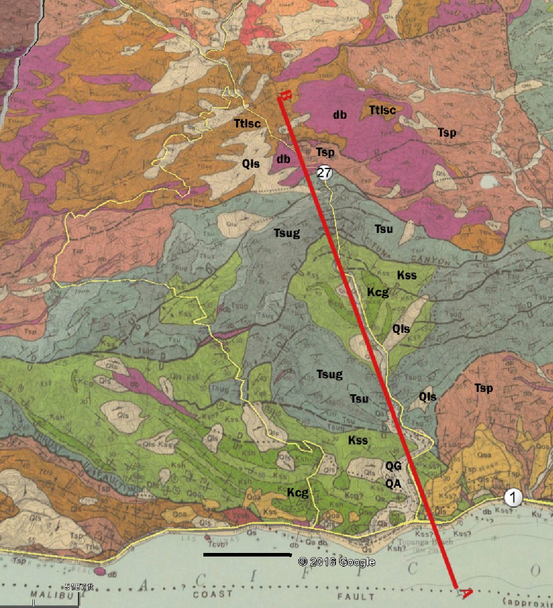
This 3.5-mile-long road log provides a quick look at the geology of Topanga Canyon along the portion that has been designated as a scenic highway. It starts from PCH and ends a bit north of the top of the S-curves
Starting northward from the Pacific Coast highway in the gently sloping lower reaches of the canyon, the road is located in the surficial sediment of Topanga Creek, stream deposits of recent age. These sediments are shown in light tan, Qa and Qg. Also shown in light tan at several places in the canyon are surficial deposits of recent landslides (<10,000 years old) that are labelled Qls. The rocks exposed in the adjacent cliffs just north of PCH, shown in green, are the oldest rocks in Topanga Canyon. They are part of the Tuna Canyon Formation (Yerkes and Campbell, 1979) and are between 100.5 and 66 million years old. The rocks are dominated by sandstone (Kss, lighter green on map), with some intervals of conglomerate (coarse-grained rocks with lots of pebbles, cobbles, and/or boulders; Kcg, darker green on map). These rocks were deposited adjacent to a long-gone ancient mountain range that directly fed sand and gravel to deeper-water submarine fans. The Tuna Canyon Formation strata in this area of Topanga Canyon are tilted and dip toward the north-northeast.
About 0.7 mile north of PCH, the rock types change abruptly because a fault (no longer active) juxtaposes the Santa Susanna Formation (shown in blue on the map) against the Tuna Canyon Formation. The Santa Susanna Formation is Eocene to Paleocene in age (66 to 34 million years old). In Topanga Canyon, it consists of two rock types, both of which were deposited in the shallow-marine environment: sandstone (Tsus, shown in the lighter blue shade) and conglomerate (Tsug, shown in the darker blue shade). The conglomerate is more resistant to erosion, and the canyon narrows as the road goes through this rock type. The direction of tilt of the rock strata also changes as the road crosses the fault. The rock strata now dip toward the south-southeast and remain that way to the top of the S-curves. The cross-section below helps illustrate this.
This cross section shows what the rock strata and fault planes look like if you sliced the Earth open along the line A-B on the map and looked at the side view of the slice.
VIEW OF CROSS SECTION HERE

About 1.0 miles north of PCH, the road crosses back into the underlying sandstone, with minor conglomerate of the Tuna Canyon Formation. Several landslide deposits occur in this formation on the hillsides on both sides of the road.
The next major change occurs about 2.2 miles north of PCH where the road crosses the Tuna Canyon fault, which is now inactive. It juxtaposes the reddish-brown conglomerate of the Tuna Canyon Formation against the light-colored sandstone of the Santa Susanna Formation. The resistant conglomerate here forms the most dramatic scenery in Topanga Canyon, as the road winds up the steep S-curves in this narrowest part of the canyon. Several small, inactive faults parallel to the Tuna Canyon fault slice and shear the Santa Susanna Formation conglomerates up to the top of the S-curves.
The final fault, 2.7 miles north of PCH, juxtaposes younger Miocene rocks of the Santa Monica Mountains against the Santa Susanna Formation. Here, the canyon widens and the gradient decreases of the road. The Miocene rocks over the next 0.8 miles include the Sespe Formation (Tsp, dark pink on the map), the Topanga Formation (Ttlsc, brown on the map), and the Conejo Volcanics (db, purple on the map. The Sespe Formation is 34 to 17 million years old and consists mostly of pink-colored sandstone and pebbly sandstone deposited in terrestrial environments of streams and deltas. The Topanga Formation is 28 to 17 million years old and consists of light-brown to orange-brown sandstone deposited in the shallow-marine environment. These rocks are famous for their marine invertebrate fossils, such as scallops and corkscrew-shaped snails. The Conejo Volcanics are 15.5 to 13.5 million years old. These rocks include both lava flows and shallow igneous intrusions that did not quite make it to the surface. The db rocks on the west side of the road above the S-curves are shallow intrusions that are dark olive gray to black in color and finely crystalline.